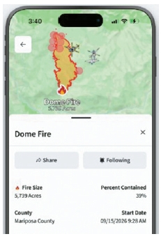
California residents can now check AwareCA app, a new public safety application that allows users to view wildfire and evacuation statuses in one place on their mobile phones.
Public safety technology company Intera recently released ‘AwareCA’ developed in cooperation with the California Department of Forestry and Fire Protection (CAL FIRE) and other California public safety agencies on the 1st. It can be downloaded for free from the Apple App Store and Google Play.
The app displays disaster occurrence status, evacuation warnings and orders, and the locations of shelters and support facilities along with maps. By registering areas of interest such as home or work and setting notification ranges, users can receive emergency alerts for their surroundings on their mobile phones.
Users can also check the location and flight paths of aircraft deployed for wildfire suppression. Caltrans traffic cameras and wildfire surveillance cameras can also be viewed directly within the app.
CAL FIRE is utilizing this app as an official public safety information platform throughout California. The purpose is to deliver information directly uploaded by firefighters and public safety agencies at the scene to residents, thereby reducing misinformation and confusion spreading on social media.
The app allows users to check not only wildfires but also various disasters and hazardous situations on a map. CAL FIRE’s current disaster information system includes various hazard information such as wildfires, floods, earthquakes, landslides, lightning strikes, and evacuation orders.
The app is free. However, the app developer advised that AwareCA is not a substitute for existing official emergency alerts, and in actual evacuation situations, the official instructions of local governments and related agencies such as fire and police must be followed first.